Services We Offer

Map your construction site or property with high resolution aerial imaging. Inspect large structures for damage or track progress during construction. Or just get a cool photo or video from a unique perspective.

High Resolution Photo and Video

A DJI Phantom 4 Pro drone is used to capture stunning 4K resolution videos at 60 frames per second and 20 mega pixel photos.

FAA Certified Pilot

With a FAA certified drone pilot (CFR 14 Part 107) we can legally fly for hire or commercially up to 400 ft AGL in uncontrolled airspace. Special clearance is required in controlled airspace and we can work with you to obtain clearance necessary for your project.

Projects Completed for Multiple Companies

What We Do

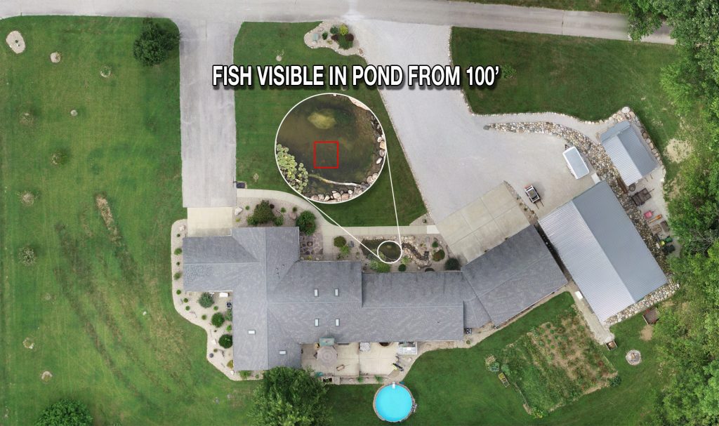
IAS (Ideal Aerial Services) specializes in offering aerial photography, inspection, and mapping services to the North-Central part of Indiana. Using sUAS (Small Unmanned Aircraft Systems) technology, IAS can capture advanced aerial footage at unique perspectives. Contact us today to learn more about what we can offer.

View Our Portfolio of Work

View Examples of Our Work on YouTube

The Face Behind the Drone

John is a FAA certified drone pilot (CFR 14 Part 107) and can legally fly for hire or commercially. Born and raised in Lafayette, Indiana, John is a Hoosier native and a graduate of Purdue University. As an aviation enthusiast and photographer, John enjoys creating new perspectives.

Checkout our LinkedIn and Google Page

More About Our Services

Mapping

Mapping services can provide customers with high resolution, up-to-date aerial maps of their construction site or property. IAS can create high resolution orthomosaic maps for almost any location. Using autopilot features and post image processing, a series of pictures are stitched together to create a large photo grid of the selected area. Detailed geographical analysis and pre and post planning can be conducted based off the assembled map. The progress of construction or renovation projects can also be documented with successive or time-lapsed aerial mapping.

Example of a high resolution map created with over forty different individual pictures stitched together to form a final image.

Inspection

IAS can provide up-to-date, high resolution images for your mission critical inspection needs. Hard to reach or inaccessible areas such as radio towers and large buildings can easily and safely be inspected using a drone. Real time progress photos of a construction site or project are also possible. Call or email us to learn more about how we can support your current or upcoming inspection or construction project.

If you are interested in any of our services please contact us for a quote!